Four Marks is a village and civil parish in the East Hampshire district of Hampshire, England, situated 4.4 miles southwest of Alton on the A31 road. It sits at approximately 630 feet above sea level, making it one of the highest villages in Hampshire. With a population of around 4,799, the village is known for Medstead and Four Marks Station on the heritage Watercress Line railway, its position on St Swithun’s Way, and its unusual name – derived from the quadripoint where four parishes once met.
What are Four Marks Hampshire United Kingdom?
Four Marks holds a distinction most English villages cannot claim: its railway station is the highest operational standard-gauge station in the whole of southern England. Medstead and Four Marks Station sits at 644 feet above sea level on the heritage Watercress Line, and the gradient climbing to it from Alton is steep enough that local railway workers nicknamed the stretch “going over the Alps.”
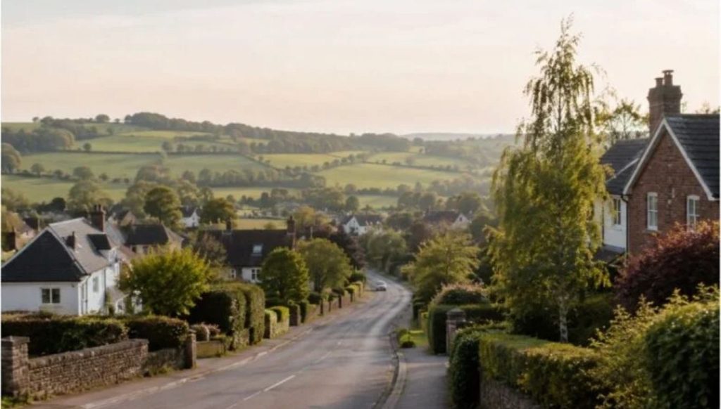
That elevation tells you something important about Four Marks Hampshire, United Kingdom. This is a high-ridge village – exposed, fresh, with wide views over Hampshire countryside – not a valley settlement huddled around a river crossing. It has no medieval castle, no cathedral connection, and barely featured in 19th-century gazetteers. Yet it grew from fewer than 100 residents in the late 1700s to nearly 5,000 today, with a story that passes through Crimean War veterans, Victorian railway politics, poultry farms, and one boundary stone that gave the place its name.
This guide covers everything you need to know about Four Marks Hampshire, United Kingdom: its origins, history, geography, transport, walking routes, community life, and what makes it one of East Hampshire’s most distinctive settlements.
Four Marks Hampshire
| Detail | Information |
| Location | East Hampshire, 4.4 miles SW of Alton |
| Civil parish | Four Marks |
| District | East Hampshire |
| Population (2011 census) | 4,799 (also cited as approx. 3,893 in 2011 data) |
| Elevation | Approx. 630 ft (192 m) above sea level |
| Postcode district | GU34 |
| Post town | ALTON |
| Dialling code | 01420 |
| OS grid reference | SU669351 |
| A-road | A31 (Alton to Winchester) |
| Railway | Medstead and Four Marks Station (Watercress Line heritage railway) |
| Walking route | St Swithun’s Way (34 miles, Winchester to Farnham) |
| UK Parliament | East Hampshire |
| Named after | Quadripoint of four parish boundaries |
| Parish established | 1932 |
The Name: What Are the “Four Marks”?
This is the question every visitor and new resident eventually asks. The answer is more precise than most people expect.
Four Marks took its name from the point where four civil parishes once met: Medstead, Ropley, Farringdon, and Chawton. Their boundaries intersected at a single quadripoint, creating what was historically marked by a large white stone noted in records from 1759. The word itself derives from the Old English “Fowremkes” – essentially “four boundary markers.”
That stone was the entire reason the place had a name at all. Neighbouring villages have far older recorded histories. Chawton and Farringdon both appear in the Domesday Book of 1086. Alresford and West Tisted are mentioned in Anglo-Saxon charters from the 8th and 10th centuries. Even nearby Medstead and Ropley appear in records by the early 13th century. Four Marks as a named settlement does not appear in records until around 1550 – because for most of its history, it was not a settlement at all. It was a point. A boundary marker on a windswept chalk ridge.
The large white boundary stone was reportedly destroyed by workmen during road construction in the 1960s. The site, near the current Boundaries surgery at approximately SU67163527, is where the four parishes originally met.
Four Marks did not become its own parish until 1932, following the 1929 Local Government Review, when seven surrounding parishes were dissolved to create it.
History of Four Marks Hampshire
Prehistoric and Roman Origins
Human activity in the Four Marks area extends far deeper than its late appearance in written records might suggest. Palaeolithic finds including flint handaxes, scrapers, and flakes have been recovered from the area, with dates potentially reaching as far back as 600,000 BCE. Mesolithic flint blades are also recorded, and Neolithic tools are particularly numerous around Four Marks and neighbouring Ropley, suggesting settlements during the later Neolithic period approximately 4,000 to 5,000 years ago.
Bronze Age finds include a bracelet and necklace unearthed during ploughing, indicating continuous human presence across thousands of years on this chalk ridge.
The Roman Road, also known historically as the King’s Highway, passed directly through the Four Marks area. It later became the Alton to Winchester turnpike – the route that is now the A31. This road has been in active use, in one form or another, for roughly two thousand years.
Crimean War Veterans and the First Settlement
Four Marks’ modern history as a lived community begins with a genuinely unusual episode. The first significant wave of settlers in the village were veterans of the Crimean War, who were allocated plots for smallholdings in the area. A number of the colonial-style houses built by these early settlers survive to this day and remain a distinctive architectural feature of the older parts of the village.
By the late 1700s, the population of the Four Marks area was likely no larger than 100. The area remained largely pasture, lanes, and the occasional barn. It did not feature in 19th-century gazetteers or hamlet listings – it was simply too small and too undefined to merit mention.
The Railway Era and Population Growth
The opening of the Mid-Hants Railway in 1865 – later to become the Watercress Line – changed the character of the area. The line connected Alton to Winchester, passing through the chalk ridge at its highest point near Four Marks. A station at Medstead was added in August 1868, originally serving the nearby ancient village of Medstead rather than Four Marks itself.
The population around Four Marks doubled in the decade to 1901, reaching 279 inhabitants and 67 dwellings. By 1911 a further increase brought 334 people and 87 homes. The station was renamed Medstead and Four Marks in October 1937 – a change approved largely because the signage needed renewal anyway – by which point Four Marks had become the more significant community and the station was already its second busiest after Alresford.
The railway closed on 4 February 1973 following the Beeching cuts. The line was listed for closure in the 1963 Beeching plan and the station closed with it. It reopened on 28 May 1983 as part of the preserved heritage railway.
20th Century Expansion
From 1961 onwards, Four Marks entered a sustained period of residential growth. The population more than tripled over the following fifty years, and the number of dwellings quadrupled. By 2011 the village recorded 3,893 inhabitants. Large-scale poultry farms dominated the agricultural landscape from the 1920s, followed by arable and dairy farming. The Muffet sisters of Brightstone Lane were a well-known fixture of 1930s village life, delivering milk daily to Four Marks residents through all weathers.
Geography and Landscape
A High-Ridge Village
Four Marks sits at approximately 630 feet (192 metres) above sea level, placing it among the highest villages in Hampshire. The chalk ridge it occupies forms part of the landscape transition between the rolling Hampshire Downs and the South Downs to the south. The elevated position gives the village its characteristic open, fresh quality – wider skies than lowland Hampshire settlements, stronger winds, and views that stretch across to surrounding farmland and woodland.
Ancient Hamlets Within the Parish
The modern parish of Four Marks encompasses several medieval hamlets that pre-date the village itself: Kitwood, Hawthorn, and Lymington. These ancient settlements now sit within what has become a relatively closely settled single community, their individual identities largely absorbed into the broader village character.
Proximity to the South Downs National Park
Four Marks sits on the borders of the South Downs National Park. This proximity shapes both the landscape character and the development constraints around the village. The finest unspoilt Hampshire countryside begins at the village’s edge, with chalk downland, ancient woodland, and managed farmland offering walking, cycling, and riding routes in every direction.
The Watercress Line: Four Marks’ Heritage Railway
No aspect of Four Marks Hampshire United Kingdom generates more interest from visitors than Medstead and Four Marks Station on the Watercress Line – and for good reason.
The Highest Station in Southern England
Medstead and Four Marks Station is the highest operational standard-gauge railway station in southern England, sitting at 644 feet (196 metres) above sea level. The gradient climbing to it from Alton is steep enough that the stretch has been nicknamed “going over the Alps” by those who work on the railway. Just east of the station building, the line reaches its absolute highest point.
The Watercress Line: History and Context
The Watercress Line is the marketing name of the Mid-Hants Railway, a heritage line running 10 miles from New Alresford to Alton. It takes its name from the Victorian practice of transporting freshly cut watercress from the Hampshire beds around Alresford to London’s Covent Garden market – a trade that shaped the local economy throughout the 19th century. The London and South Western Railway originally operated the line, purchasing the Mid-Hants Railway Company in 1884.
The line became part of Southern Railway in 1923, then Southern Region of British Railways in 1948, before closure in 1973. Preserved volunteers reopened it in stages from 1977, reaching Medstead and Four Marks in 1983 and the full Alton terminus in 1985.
The Station Today
The station has been restored to represent its appearance in the immediate post-war period under Southern Railway, circa 1945 to 1947. Period posters, a restored stationmaster’s house, and the careful preservation of original platform structures give it an authentic atmosphere that the Watercress Line carries well.
One detail worth knowing: the signal box at the station came from Wilton South station, and the footbridge came from Cowes railway station on the Isle of Wight – two pieces of railway heritage quietly relocated to Hampshire. The station is staffed almost entirely by volunteers, as is the rest of the Watercress Line.
Station Timeline
| Date | Event |
| August 1868 | Station opened as “Medstead” |
| 1 October 1937 | Renamed “Medstead and Four Marks” |
| January 1967 | Signal box closed, down platform taken out of use |
| 4 February 1973 | Station closed with the line |
| 28 May 1983 | Reopened as part of the Watercress Line heritage railway |
Walking: St Swithun’s Way and Local Routes
Four Marks sits approximately halfway along St Swithun’s Way, a 34-mile waymarked walking route connecting Winchester Cathedral to Farnham in Surrey. The route is named after St Swithun, the 9th-century Bishop of Winchester, and follows a stretch of the ancient Pilgrims’ Way – the historic route taken by pilgrims travelling from Winchester to the shrine of Thomas Becket at Canterbury Cathedral.
The southwestern fringe of Four Marks village lies directly on this route. Walkers completing St Swithun’s Way pass through the village as part of a multi-day journey that links two of southern England’s most significant historic routes: the South Downs Way at Winchester and the North Downs Way at Farnham.
Day Walks from Four Marks
| Walk | Distance | Highlights |
| Barrow to Quorn (local loop) | Under 3 miles | River, canal, fields |
| St Swithun’s Way section | Flexible | Pilgrims’ route, chalk downland |
| Watercress Line walk | Ropley to Four Marks station | Heritage railway landscape, Great British Life featured route |
| South Downs border paths | Variable | South Downs National Park fringes |
| Chawton Park Wood | Variable | Ancient woodland, Roman road traces |
The Watercress Line walking route between Ropley and Medstead and Four Marks Station is described in Great British Life as particularly scenic, following the railway through Hampshire countryside with short linking paths to each station. The area around Chawton Park Wood to the west carried a notorious reputation for highway robbers in earlier centuries – an area north of the railway still known as “Gibbet Copse” marks that history on the landscape today.
Transport and Connectivity
Road: The A31 Corridor
Four Marks sits directly on the A31, the main road connecting Alton to Winchester. This trunk road has followed essentially the same alignment since it replaced the old Alton to Winchester turnpike in 1753 – itself following the Roman King’s Highway that preceded it. The result is a village with direct, fast road access to Alton (approximately 5 to 10 minutes northeast) and Winchester (approximately 20 minutes southwest).
Heritage Railway: Visitor Access Only
Medstead and Four Marks Station provides Watercress Line services, but it is important to be clear: this is a heritage railway, not a commuter service. There are no regular national rail connections from the village. Residents commuting by rail typically drive to Alton station (4.4 miles northeast), which sits on the national network with services to London Waterloo.
Nearest Towns and Cities
| Destination | Approximate Distance | Travel |
| Alton | 4.4 miles NE | A31, approx. 10 minutes |
| Winchester | Approx. 14 miles SW | A31, approx. 20 minutes |
| Farnham | Approx. 12 miles NE | A31 / A325 |
| Basingstoke | Approx. 15 miles N | A339 |
| Southampton | Approx. 25 miles SW | M3 |
Community, Amenities, and Village Life
Recreation
Four Marks has a large recreation ground serving the community with football and cricket pitches, tennis courts, a bowls club, and BMX ramps. Four Marks F.C., the village football club, was founded in 1921 and continues to operate at Upland Lane, competing in the Farnham and District League under the Hampshire Football Association. The club played in the Aldershot and District League for many years before joining the North Hants League in 1978.
Fetes, galas, and horse racing were established as annual village events from the early years of the settled community, a tradition that continues in modified form through the current community calendar.
Schools and Services
The village is served by primary education locally, with secondary school pupils typically accessing schools in Alton. Healthcare provision includes the Boundaries surgery, which sits near the historic quadripoint site that gave the village its name. The village supports a functioning range of local shops, services, and independent businesses along its main routes.
Architecture and Housing Character
The Crimean War colonial-style houses from the village’s founding settlement phase remain visible among the broader housing stock. The 20th-century expansion brought extensive estate development alongside earlier individual plots, creating a mixed architectural character. Wikishire notes that the last decade has seen an explosion in piecemeal and large estate development – a pattern that reflects Four Marks’ ongoing appeal to buyers seeking East Hampshire countryside with A31 accessibility.
Medieval Hamlets: Kitwood, Hawthorn, and Lymington
A detail the competitor article misses entirely: the Four Marks parish contains three medieval hamlets within its boundaries. Kitwood, Hawthorn, and Lymington predate the modern village by centuries, their names embedded in the local landscape long before the quadripoint boundary stone marked the ridge as “Four Marks.” All three are now absorbed into the relatively closely settled parish, but their names survive in local place references and reflect the ancient agricultural character of this chalk ridge before Victorian expansion.
FAQs
Where is Four Marks in Hampshire?
Four Marks is a village in the East Hampshire district, situated 4.4 miles (7.1 km) southwest of the market town of Alton, on the A31 road. It sits on the border of the South Downs National Park and lies approximately 14 miles northeast of Winchester. The postcode district is GU34.
Why is it called Four Marks?
The name derives from a quadripoint where four civil parishes once met: Medstead, Ropley, Farringdon, and Chawton. The word comes from the Old English “Fowremkes” meaning four boundary markers. A large white boundary stone marked the exact meeting point from at least 1759 until it was destroyed by road workers in the 1960s. Four Marks did not become its own parish until 1932.
How high above sea level is Four Marks?
Four Marks village sits at approximately 630 feet (192 metres) above sea level. The Medstead and Four Marks Station on the Watercress Line sits at 644 feet (196 metres), making it the highest operational standard-gauge railway station in southern England.
Does Four Marks have a railway station?
Yes, but with an important qualification. Medstead and Four Marks Station serves the heritage Watercress Line, a preserved steam railway running 10 miles between Alton and New Alresford. It is not a National Rail commuter service. Residents using the national rail network typically drive to Alton station (4.4 miles away) for services to London Waterloo and beyond.
What is the Watercress Line?
The Watercress Line is the marketing name of the Mid-Hants Railway, a 10-mile heritage steam railway running through Hampshire from New Alresford to Alton. It takes its name from the Victorian trade of transporting locally grown watercress to London’s Covent Garden market. The original line opened in 1865, closed in 1973, and was restored by volunteers reopening in stages from 1977, reaching Four Marks in 1983.
What walking routes pass through Four Marks?
St Swithun’s Way, a 34-mile waymarked route from Winchester Cathedral to Farnham in Surrey, passes through the southwestern fringe of Four Marks. The route follows part of the ancient Pilgrims’ Way used by travellers heading to Canterbury. The Watercress Line walking route also passes through, and the South Downs National Park borders the village to the south.
What is the population of Four Marks Hampshire?
The 2011 census recorded approximately 3,893 to 4,799 residents (figures vary by source and exact parish boundary). From the late 1700s, when the population was likely under 100, to today’s near-5,000 residents, Four Marks has grown dramatically, with population more than tripling between 1961 and 2011 alone.
What are the medieval hamlets within Four Marks parish?
The Four Marks parish contains three medieval hamlets: Kitwood, Hawthorn, and Lymington. All three predate the modern village and are now absorbed into the broader parish settlement. Their names reflect the ancient agricultural character of the chalk ridge before Victorian and 20th-century development.
Who were the first settlers of Four Marks?
The first significant wave of settlers in the modern village were veterans of the Crimean War, allocated smallholding plots in the area. A number of the colonial-style houses they built survive today in the older parts of the village. Before this settlement, the area had a population likely no larger than 100 in the late 1700s.
Is Four Marks near the South Downs?
Yes. Four Marks sits on the borders of the South Downs National Park. The village’s elevated chalk ridge position places it adjacent to some of the finest unspoilt Hampshire countryside, with access to South Downs walking routes, bridleways, and countryside immediately at the village edge.
What sport and leisure facilities does Four Marks have?
The village has a large recreation ground with football and cricket pitches, tennis courts, a local bowls club, and BMX ramps. Four Marks F.C. football club, founded in 1921, plays at Upland Lane. Community events including fetes and galas have been a village tradition since the earliest years of the settled community.
How far is Four Marks from Winchester?
Four Marks is approximately 14 miles northeast of Winchester, connected directly by the A31. The journey by road takes approximately 20 minutes. St Swithun’s Way, the 34-mile walking route beginning at Winchester Cathedral, passes through Four Marks approximately halfway along its length.
Conclusion
Four Marks Hampshire United Kingdom earns its character the hard way – not through medieval grandeur or famous associations but through a specific geography, an unusual name origin, and a growth story spanning Crimean War smallholdings to modern commuter estates. The village sits higher than almost anything else in Hampshire, its station holds a genuine record for the whole of southern England, and pilgrims have been walking through its southern fringe for centuries.
For visitors, the Watercress Line and St Swithun’s Way provide two excellent reasons to spend a day here. For prospective residents, the A31 access, South Downs proximity, recreation facilities, and community infrastructure make it a compelling East Hampshire choice. Explore the Watercress Line’s full 10-mile journey between Alton and New Alresford, or walk a section of St Swithun’s Way through the village and south towards Winchester for a genuine sense of the landscape Four Marks occupies.
Planning your next escape? If you love exploring remote and untouched landscapes, check out our ultimate Lucipara travel guide to discover one of Indonesia’s most pristine tropical paradises.

Hi, I’m Sidra Azeemi, a freelance content writer and guest post specialist with 3+ years of experience. I offer content writing and on-page SEO services. I write about celebrities, net worth, and entertainment.