Table of Contents
Rome did not build the ancient world’s most powerful empire through military force alone. Cesta Roman, the Roman road network, gave legions unmatched speed, gave merchants reliable routes across three continents, and gave emperors real administrative control over territories they would never personally visit.
These were not dirt paths worn down by repeated foot traffic. They were precisely engineered, deliberately layered, and centrally planned systems built to last for centuries, and in many places they did exactly that. Understanding “cesta roman” means understanding one of history’s most consequential decisions: that durable physical infrastructure is the foundation of every other kind of power.
What Does “Cesta Roman” Mean?
The phrase translates directly to “Roman road.” The word “cesta” refers to a constructed path or way, something deliberately built rather than naturally formed by use. “Roman” places it within a specific philosophy of governance where roads functioned as instruments of state power, not simply as conveniences for travelers.
In Roman thinking, every road carried authority. Each mile of paved stone announced that the empire was present, organized, and permanent. These paths were political statements carved into the landscape of every territory Rome controlled, and they communicated that presence to anyone who traveled them, whether Roman citizen, provincial resident, or potential rebel.
Some historians draw a connection between “cesta” and concepts of shared communal space, reflecting how Roman roads became woven into the social fabric of every province they crossed. They shaped where markets formed, where cities grew, and how communities understood their relationship to the wider empire.
Historical Origins and Early Development
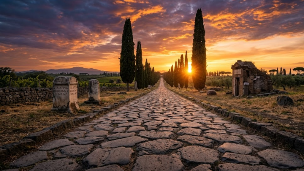
Roman road construction began in 312 BC with the Via Appia, the first major paved route heading south from Rome toward the southern Italian territories. This was not an experimental project. It was a confident, large-scale infrastructure commitment made at a time when Rome was actively expanding its territorial reach and needed reliable systems to support that expansion.
From that starting point, the network grew steadily outward over the following centuries. Builders adapted their methods to different ground conditions across different regions, adjusting foundation materials and surface treatments based on local terrain and geology. What they never adjusted was the underlying standard: every road had to be deep, layered, drainable, and as straight as the landscape allowed.
By the peak of Roman imperial power in the first century AD, roads stretched into North Africa, Western Asia, Britain, and across most of continental Europe. Archaeological evidence gathered from inscriptions, coins, and artifacts found along verified road corridors confirms that these routes served far more than military movement.
They carried communities, commerce, government communication, and cultural exchange across an empire that no single person could physically oversee.
How Roman Roads Were Actually Built
The durability that makes cesta roman roads a subject of ongoing engineering admiration came directly from the discipline of their construction process. Roman builders did not improvise. They followed a strict sequence of layered materials, each serving a specific structural function, and none of those layers could be skipped without compromising the whole road.
Workers began by digging a trench along the surveyed route. Into that trench they packed large foundation stones, a layer called the statumen, which created a stable load-bearing base capable of handling the weight of loaded carts, marching armies, and daily civilian traffic over decades without settling or shifting.
Above the foundation stones, builders added a layer of compacted rubble mixed with lime mortar, called the rudus, which provided structural stability and began the transition from raw earth to engineered surface.
Above that came the nucleus, a layer of fine gravel or sand that leveled the surface and helped bind the materials below into a coherent structure. The final layer, called the summum dorsum, consisted of tightly fitted paving stones laid precisely to create a firm, weather-resistant surface that could support continuous heavy use.
Every layer served the whole. This was not over-engineering. It was the minimum required to build something intended to last.
Surveying and Drainage
Roman surveyors used two primary tools to achieve the straightness that defines these roads. The groma established precise straight sight lines across long distances. The chorobates functioned as a leveling device to maintain consistent elevation profiles. Together, these instruments allowed engineers to plan routes that minimized unnecessary turns while accounting for terrain realities.
Drainage was never an afterthought. Roads were built with a slight camber, meaning the surface rose gently toward the center, so that rainwater ran naturally off to either side into roadside drainage ditches.
This prevented water from pooling on the surface, stopped mud from accumulating, and kept road surfaces firm and reliable through wet seasons. The combination of deep foundations and active drainage also countered the freeze-thaw cycles that destroy modern pavement over time by preventing water from penetrating the structure and expanding as it froze.
Key Design Features That Set Cesta Roman Apart
Several specific design choices gave Roman roads capabilities that roads built by other ancient civilizations consistently lacked.
Milestones placed at regular intervals along every major route gave travelers and military planners reliable information about distances. Officials used them to coordinate troop movements, plan supply chain logistics, and schedule courier routes. The mere presence of a milestone bearing an emperor’s name communicated imperial reach into remote territories without requiring soldiers to be permanently stationed there.
Surface hardness came from locally sourced stones selected and mixed to create wear-resistant paving that could absorb years of heavy cart traffic without significant degradation. Maintenance costs stayed low because the materials were chosen for longevity rather than immediate convenience.
The commitment to straight routing between points reduced travel time dramatically compared to routes that wound around natural obstacles. Where hills or valleys made straight routing impractical, Roman engineers cut through terrain or built bridges and viaducts rather than routing around, because they understood that distance added to a route was a permanent cost paid by every traveler who used it for centuries.
Why Rome Built Roads: Military, Economic, and Administrative Power
| Aspect | Impact of the Road Network |
| Military | Doubled the speed of legions; rapid response to revolts. |
| Economic | Predictable transit times; empire-wide trade and taxation. |
| Administrative | Fast courier systems (Cursus Publicus); centralized control. |
| Cultural | Spread of Latin, Roman Law, and religious movements. |
Military Speed and Reach
Roman legions could cover approximately 30 kilometers per day on paved roads, roughly double the pace achievable on unpaved terrain in comparable conditions.
That speed advantage transformed the strategic landscape of the empire. Revolts in distant provinces could be suppressed before they spread and gathered momentum. Supply lines reached frontier territories reliably, which kept legions operational far from Italian bases. Coordinated troop movements across vast distances became feasible in ways that simply were not possible without reliable roads.
The road network did not just support the Roman military. In many ways it was the military’s single most powerful strategic asset.
Economic Integration Across the Empire
Merchants moved grain, olive oil, wine, metals, textiles, and luxury goods across the empire with a level of predictability that had been impossible before the road network existed. Reduced transport costs and reliable transit times meant regional economies could specialize in what they produced best and trade for everything else, rather than remaining isolated and self-sufficient out of necessity.
Markets expanded dramatically. Artisans in one province reached buyers in another. Rome taxed the movement of goods along every route, which meant that the infrastructure investment generated direct ongoing revenue. The roads were not just an expenditure. They were a revenue system.
Administrative and Cultural Control
The cursus publicus, Rome’s official state communication network, ran entirely on roads. Government couriers carried official messages, legal rulings, and imperial orders between provinces in days rather than weeks. Governors could administer distant territories because information moved quickly enough to keep them genuinely informed and capable of responding to events.
Roads also carried culture. Latin spread along trade corridors as merchants and soldiers brought the language into provincial cities and towns. Roman legal systems took root because administrators traveled the same routes that merchants used. Christianity spread through the empire at a significant speed, partly because the infrastructure for reliable movement already existed and was available to anyone who needed it.
The Four Layers of Cesta Roman
| Layer Name | Material Used | Primary Purpose |
| Statumen | Large, heavy stones. | Solid foundation; prevents sinking. |
| Rudus | Rubble and lime mortar. | Structural stability and leveling. |
| Nucleus | Fine gravel or sand. | Binding layer; absorbs vibrations. |
| Summum Dorsum | Polygonal paving stones. | Weather-resistant, smooth surface for carts. |
The Most Important Roman Roads
The Via Appia remains the most famous Roman road, running south from Rome through Capua and eventually reaching the southeastern port city of Brindisi. It was the first major route built and set the engineering standard that all later roads followed. Sections of it remain walkable today.
The Via Egnatia crossed from the Adriatic coast eastward to Byzantium, connecting Rome’s western territories to the Greek world and beyond. It remained a significant route through the Byzantine Empire and even into Ottoman times, which stands as remarkable evidence that well-planned infrastructure outlives the political systems that build it.
The Via Flaminia ran northward from Rome and served as the primary military route for operations in northern Italy and beyond. The Via Aurelia followed the western Italian coast and supported coastal trade. The Via Augusta crossed the Iberian Peninsula and helped unify Roman Spain as a functioning part of the empire rather than a collection of disconnected provincial territories.
The True Scale of the Roman Road Network
The numbers that describe the Roman road network remain striking even when measured against modern infrastructure.
The total network covered approximately 400,000 kilometers across the empire. Of that total, roughly 80,000 kilometers consisted of stone-paved surface built to the full layered construction standard. The network crossed three continents: Europe, North Africa, and Western Asia.
This was not organic growth that accumulated gradually without planning. It was centrally planned, consistently executed, and quality-controlled across centuries of construction activity. No other ancient civilization built at this scale with this level of standardization, and the results are still visible in the landscape of Europe and the Mediterranean world today.
Cultural Significance and Lasting Legacy
Roman roads became embedded in the cultural identity of every region they crossed. Markets organized themselves around road junctions. Cities grew at intersections where routes met and trade naturally concentrated. Roman architecture, legal traditions, and urban planning followed roads into new territories because the roads made administrative presence possible.
The legacy of cesta roman extends into modern life in ways that most people never consciously notice. London, Paris, Milan, Cologne, and dozens of other major European cities developed their foundational urban layouts along routes that Roman planners established. Walk through the oldest districts of any major Western European city, and you walk along corridors that Roman engineers first surveyed.
The sophistication of Roman urban planning, including city grids, public spaces, and the placement of water infrastructure, all depended entirely on road access that the cesta roman network provided. Without the roads, the cities could not have existed in the form that shaped European civilization.
The Psychology and Symbolism of Straight Roads
The straightness of Roman roads did more than reduce travel time. It communicated power in ways that curved or winding paths simply cannot.
A perfectly straight road cutting across a landscape at a consistent width told every traveler that Rome had surveyed, planned, and formally claimed that territory. The road did not ask permission from the landscape. It imposed order on it. Milestones bearing imperial names reinforced this message at regular intervals. Travelers in the most distant provinces understood, without needing to see soldiers present, that they were inside Rome’s administrative reach.
This psychological effect reduced resistance to Roman authority and normalized imperial presence across territories that would otherwise feel ungoverned and remote. Infrastructure communicated what armies could not maintain permanently. It made the empire feel like a natural condition rather than an occupation.
What Archaeology Still Reveals
Ongoing excavations across the Mediterranean continue to confirm the precision and durability of Roman road construction. Wheel ruts etched into stone surfaces at known Roman sites show the volume of cart traffic these roads handled over their working lifetimes. Drainage channels excavated at road sites remain structurally sound after more than 2,000 years. Road alignments identified through excavation match modern GPS mapping within meters.
That final point is worth pausing on. Satellite imagery shows Roman routes and modern European highways running parallel, or in some cases completely identical, across large stretches of the continent. Roman engineers chose those routes because they represented the most geographically efficient paths available. Modern engineers, using advanced surveying technology, reached the same conclusions centuries later.
Conservation programs across Italy, Britain, France, Spain, and other European countries work to maintain structural integrity at preserved road sites while making them accessible to researchers and the public. These sites function as active educational resources for schools, universities, and archaeological research institutions.
What Cesta Roman Teaches Modern Infrastructure Planning
Modern road design still draws directly from Roman principles. Load-bearing foundation layers that distribute weight across multiple strata rather than concentrating it at the surface; straight routing that prioritizes efficiency over minimal initial cost; and integrated drainage systems designed at the planning stage rather than added as corrections later, all of these trace back to methods Roman engineers developed and standardized over two millennia ago.
Contemporary urban planners and civil engineers reference Roman infrastructure is not out of historical nostalgia but because the underlying logic remains sound. Build for longevity. Plan for drainage from the beginning. Route for long-term efficiency rather than short-term ease. Design systems that serve multiple users and purposes simultaneously. These are not ancient insights that modern practice has superseded. They are principles that modern practice keeps rediscovering.
The fragmentation of regions that lost access to Roman road networks after the empire’s decline illustrates, in stark reverse, what roads made possible when they existed. Trade contracted. Administrative communication slowed. Cultural exchange diminished. The roads had not just facilitated those activities. They had made them possible at scale.
Common Misconceptions About Roman Roads
The most persistent misconception is that Roman roads existed primarily to move armies. Military logistics were certainly a major reason Rome invested so heavily in road construction. But civilian use, including commercial trade, government communication, religious pilgrimage, and ordinary migration, drove much of the daily traffic on these routes throughout the empire’s history.
Another common mistake is imagining every Roman road as a perfectly straight line drawn across any terrain, regardless of geography. Roman engineers were pragmatic. They balanced directness with terrain intelligence, drainage requirements, and long-term structural viability. Where straight routing was not practical, they adapted the alignment without abandoning the construction standards that made roads last. The straightness people associate with Roman roads reflects good planning in favorable terrain, not a rigid rule applied regardless of conditions.
Conclusion
Cesta Roman was infrastructure and political ideology combined into a single physical system. It moved armies, merchants, laws, languages, and ideas across three continents for centuries, and it did so because the people who built it understood something that infrastructure projects still struggle to apply consistently: systems built for longevity, with drainage and load distribution and long-term routing efficiency built into the design from the beginning, outlast systems built for speed or minimum immediate cost.
The roads themselves stand as historical artifacts that archaeologists, engineers, and historians continue studying today. The thinking behind them remains immediately applicable to any project where the goal is infrastructure that serves its users reliably, not for years but for generations.
FAQs
What does “cesta roman” mean? “Cesta romana” translates directly to “Roman road.” It refers to the engineered network of constructed paths the Roman Empire built to connect provinces, cities, and military locations across Europe, North Africa, and Western Asia.
When did Rome start building roads? Construction began in 312 BC with the Via Appia running south from Rome toward the Italian territories. The network expanded continuously for several centuries as the empire grew and new territories required connection to the central administration.
Why are Roman roads still visible more than 2,000 years later? Their layered stone multiple foundation strata, combined with integrated drainage systems and tightly fitted surface paving gave them exceptional structural durability. Many sections have survived wars, centuries of weather, and long periods of neglect without fundamental structural failure.
Were Roman roads used only by the military? No. While military logistics drove much of the initial investment in road construction, Roman roads carried merchants, ordinary civilians, government couriers, religious travelers, and cultural exchange throughout their daily use. Trade and governance depended on the same routes as troop movements.
Do modern European roads follow Roman routes? Many do. GPS mapping and satellite imagery confirm that modern European highways run parallel to, or directly over, Roman road paths across large stretches of the continent. This happens because Roman engineers chose geographically efficient routes that remain practically optimal today.
What is the most important lesson Cesta Roman offers modern planners? Infrastructure built with a genuine long-term vision, prioritizing drainage, durability, and system-level efficiency over short-term convenience or minimum initial cost, can outlast the political structures that created it and continue delivering value for centuries after those structures disappear.

Hi, I’m Sidra Azeemi, a freelance content writer and guest post specialist with 3+ years of experience. I offer content writing and on-page SEO services. I write about celebrities, net worth, and entertainment.